If you travel with a camera, start here — the most photogenic places of the whole journey.
Tap any photo to open it full-screen and order a print.
01 / 06

Milford Sound
Milford Sound, in Fiordland National Park, is a glacier-carved fiord where sheer cliffs rise more than a kilometer straight from dark water. Among the wettest inhabited places on Earth, its frequent rain feeds hundreds of temporary waterfalls that pour from the cliffs.
Despite its name, Milford Sound is technically a fiord, gouged by glaciers and flooded by the sea. Mitre Peak, rising 1,692 meters almost directly from the water, is its defining landmark and one of the most photographed mountains in the country. The fiord lies within Te Wahipounamu, a UNESCO World Heritage area, and is reached by a single road from Te Anau that itself passes alpine valleys, the Mirror Lakes and the Homer Tunnel.
Explore Milford Sound →02 / 06

Goreme
Göreme sits at the heart of Cappadocia, a region of soft volcanic rock eroded into cones, pillars and valleys. The town is built into and among the formations, with cave dwellings, rock-cut churches and a celebrated dawn balloon flight over the landscape.
The surrounding terrain, shaped by ancient eruptions and erosion, is dotted with the tapering rock pillars known as fairy chimneys, many hollowed out into homes, hotels and churches. The nearby Göreme Open-Air Museum preserves a cluster of rock-cut Byzantine churches with frescoed interiors carved into the cliffs.
Explore Goreme →03 / 06

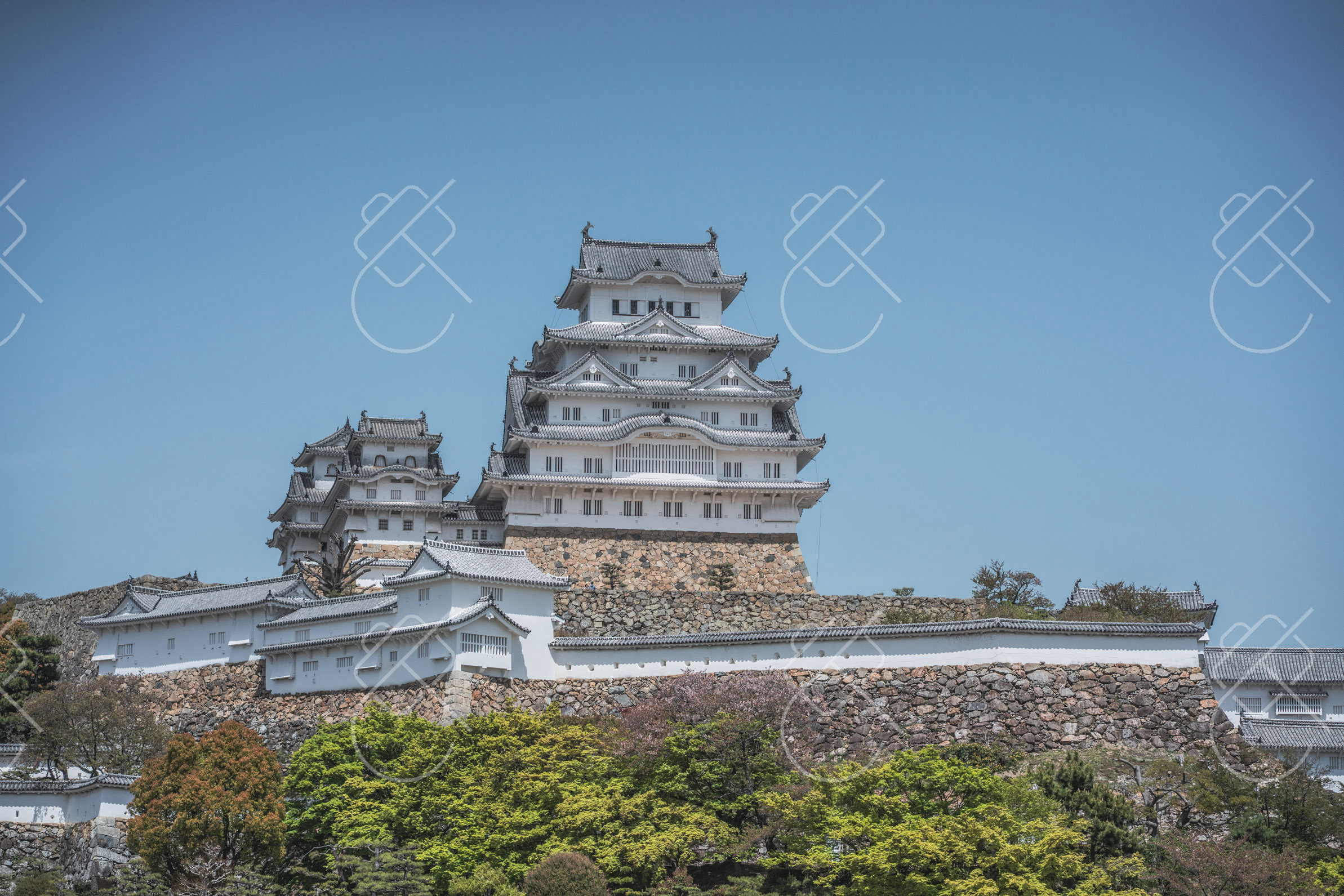
Kyoto
Kyoto was Japan's imperial capital for more than a millennium and preserves an exceptional density of temples, shrines, wooden townhouses and traditional gardens. Many of its sites are UNESCO World Heritage listed, and entire districts retain a historic streetscape.
The city's landmarks range from the gold-leafed Kinkaku-ji pavilion reflected in its pond to the thousands of vermilion torii gates winding up the hillside at Fushimi Inari Shrine. The eastern Higashiyama district preserves stepped lanes of wooden machiya houses leading to the hillside Kiyomizu-dera temple, whose large wooden terrace overlooks the city.
Explore Kyoto →04 / 06

Erg Chigaga
Erg Chigaga is the largest and most remote field of Saharan dunes accessible from southern Morocco, reached by a long off-road drive beyond the end of the paved road at M'Hamid. Its isolation keeps it far quieter than Morocco's more visited dune fields.
The erg stretches roughly 40 kilometers and rises to dunes of around 300 meters, forming a broad sea of sand without nearby towns or roads. Access requires a four-wheel-drive vehicle, and most visitors stay in tented desert camps set among the dunes.
Explore Erg Chigaga →05 / 06

Hoi An
A preserved trading port glowing with silk lanterns along a riverside old town.
Hoi An was a major Southeast Asian trading port between the 15th and 19th centuries, and its remarkably intact old town is a UNESCO World Heritage Site. The architecture blends Vietnamese, Chinese, Japanese and European influences in a compact, vehicle-free riverside core of wooden shophouses, assembly halls and a famous covered bridge. Much of it is painted a distinctive weathered yellow.
Explore Hoi An →06 / 06

Chefchaouen
Chefchaouen sits in the Rif Mountains of northern Morocco, a small town famous for the powder-blue wash that covers its medina walls, doors and stairways. The cool mountain setting and consistent blue palette make it one of the country's most distinctive places to photograph.
Founded in 1471, Chefchaouen was long closed to outsiders and absorbed waves of Andalusian and Jewish refugees from Spain. The tradition of painting the medina blue is variously attributed to Jewish residents, to cooling the buildings, or to repelling insects; whatever its origin, the result is a town of narrow stepped lanes in every shade from sky to indigo, set against the green slopes of the Rif.
Explore Chefchaouen →