Indonesia is the world's largest archipelago, made up of more than seventeen thousand islands, and Bali is its best-known destination — a single Hindu-majority island within a predominantly Muslim nation. Bali concentrates an extraordinary range of landscapes into a small area: sculpted rice terraces, active volcanoes, crater lakes, jungle waterfalls, surf beaches and thousands of temples. A distinctive Hindu culture shapes daily life through ceremonies, offerings and temple festivals, and the tropical light is strong, the green of the terraces vivid after rain.
Ubud, in Bali's central uplands, is regarded as the island's cultural heart, a town of art, dance and temples surrounded by emerald rice terraces and river gorges. It draws visitors seeking traditional crafts, yoga and the landscapes of the central highlands.
Surrounded by paddy fields and ravines, Ubud has long been a center for Balinese painting, woodcarving and dance, with a royal palace and numerous temples in and around the town. Just north, the Tegallalang Rice Terraces descend a steep valley in the sculpted curves of the traditional subak irrigation system, recognized by UNESCO, and are among the most photographed landscapes in Bali, best in the green months and the soft light of early morning.
Nearby lie the Tegenungan and other waterfalls, the Goa Gajah or Elephant Cave with its carved entrance, and the Tirta Empul water temple where worshippers bathe in sacred springs. The Campuhan Ridge Walk offers an easy path along a green spine above the river valleys, and the Sacred Monkey Forest preserves a temple complex inhabited by long-tailed macaques in the heart of town.
When to go: The dry season (April–October) offers the best weather for rice terraces and temples; visit in June for the Bali Arts Festival, avoiding the wetter, humid months.
Where to stay: Staying in or just outside central Ubud places the town's temples, markets and the surrounding rice terraces within easy reach.
What to eat: Babi guling (Balinese suckling pig), bebek betutu (slow-cooked duck), nasi campur, and fresh tropical fruit from the markets.
Tip: The Tegallalang terraces face the morning sun and fill with visitors by mid-morning, so arriving at first light gives both soft side-light and emptier frames.
Explore Ubud →
Seminyak is a beach resort area on Bali's southwest coast, north of Kuta, known for its long surf beach, sunset bars, boutiques and a temple set on offshore rocks nearby. It is the island's most developed strip of coastal nightlife and dining.
Seminyak's wide, west-facing beach runs for several kilometers and is famed for its sunsets, drawing crowds to beachfront bars at the end of the day. More upmarket than neighboring Kuta, the area is lined with designer boutiques, spas and restaurants, and it serves as a convenient base for the southern coast. The surf is consistent, and the flat sand reflects the colored sky after the sun drops below the Indian Ocean.
A short distance up the coast at Tanah Lot stands one of Bali's most iconic temples, perched on a rock formation in the sea and accessible across the sand only at low tide. Built to honor the sea gods, the temple is silhouetted dramatically against the sunset and is among the most photographed sites on the island. The surrounding southern beaches at Canggu and Echo Beach continue the surf and sunset scene.
When to go: April to October is the dry season, ideal for beaches and sunsets; July and August are busiest, while the November–March wet season brings afternoon downpours.
Where to stay: Seminyak itself offers beachfront resorts and easy access to the sunset bars, with nearby Canggu a quieter, surf-focused alternative.
What to eat: Fresh grilled seafood, Indonesian staples such as nasi goreng and satay, and an international dining scene catering to visitors.
Tip: Tanah Lot is only reachable across the sand at low tide and is busiest at sunset, so checking the tide table and arriving early secures a clear foreground for the temple silhouette.
Explore Seminyak →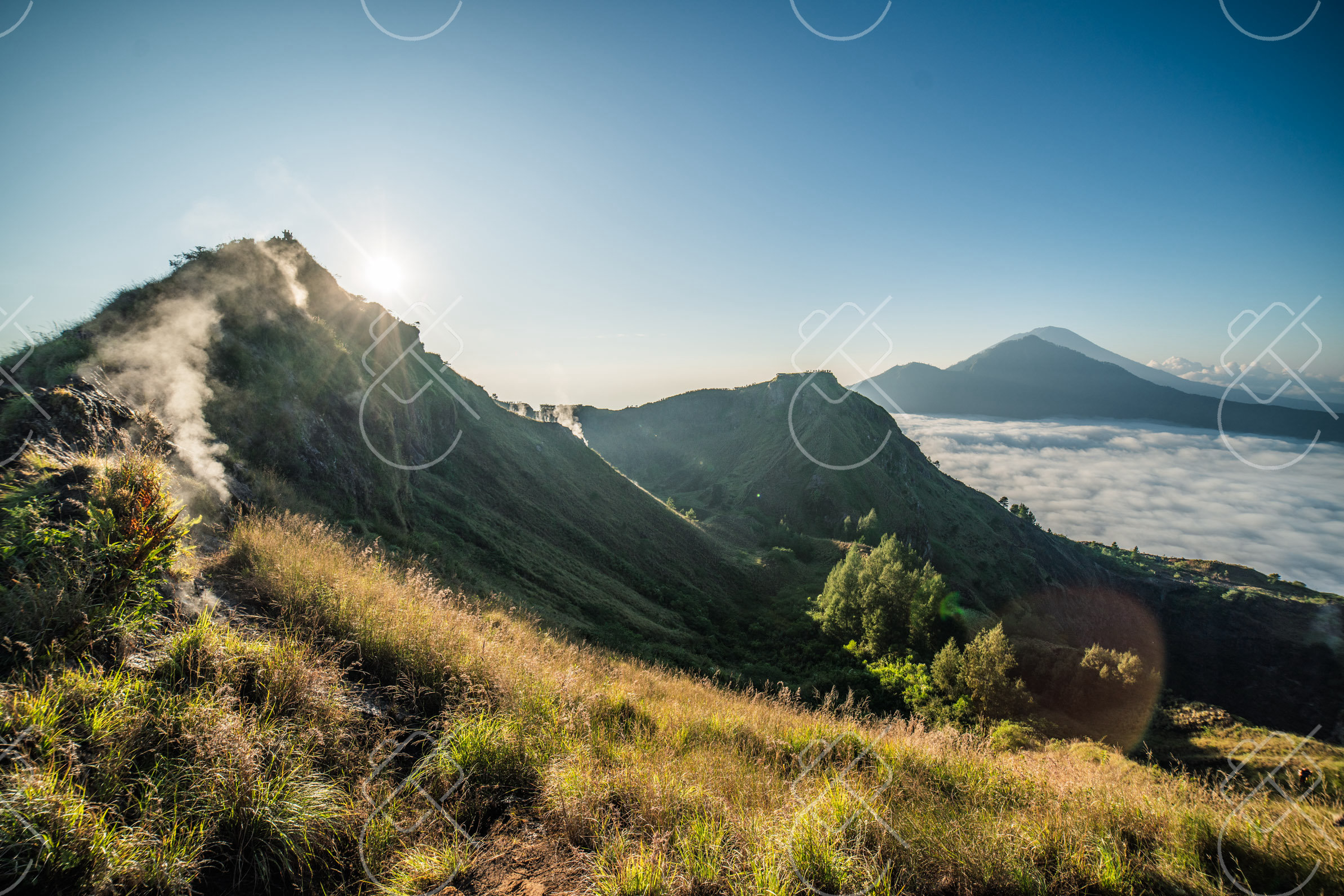
Kintamani, in Bali's northeastern highlands, overlooks the vast caldera of Mount Batur, an active volcano rising above a crescent crater lake. The cool, elevated region is known for sweeping volcanic views and sunrise treks.
The Kintamani region sits on the rim of an ancient caldera, with the active cone of Mount Batur, at around 1,717 meters, rising from the caldera floor beside the dark expanse of Lake Batur, the largest lake on Bali. The whole landscape is part of a UNESCO Global Geopark. Viewpoints and restaurants along the rim look out across the volcano and lake, and the cooler air at altitude contrasts with the lowland heat.
Sunrise treks up Mount Batur are among Bali's most popular activities, with hikers climbing in the dark to reach the summit as the sun rises over the caldera and the neighboring peak of Mount Agung. The slopes are dotted with old lava flows from past eruptions, and the area also holds hot springs along the lakeshore and the lakeside temple of Ulun Danu Batur.
When to go: Visit in the dry season (April–October) for clear views of Mount Batur and comfortable trekking; this highland area is cooler than the coast year-round.
Where to stay: Lodging along the caldera rim around Penelokan gives direct volcano and lake views, while lakeside Toya Bungkah suits trek starts and hot springs.
What to eat: Grilled lake fish from Lake Batur, and the cool-climate produce, including citrus and coffee, grown on the volcanic slopes.
Tip: The Batur sunrise trek starts in darkness and reaches the summit as the light comes up, so a headlamp and warm layers are needed at altitude before the sun warms the caldera.
Explore Kintamani →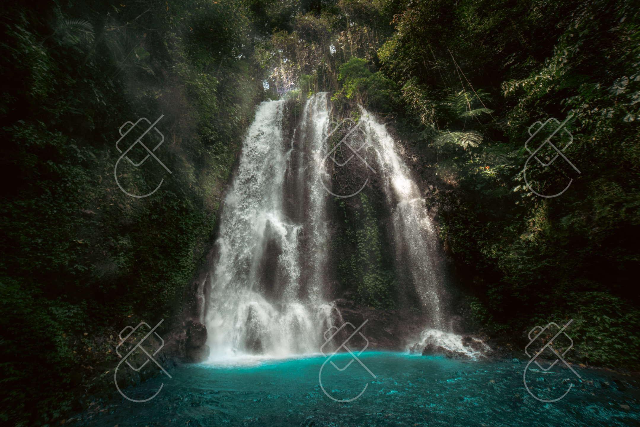
Munduk is a mountain village in Bali's northern highlands, set among coffee and clove plantations and known for its cool climate, jungle waterfalls and nearby crater lakes. It offers a quieter, greener side of the island away from the southern beaches.
Perched on a ridge at around 800 meters, Munduk is surrounded by dense forest and terraced plantations, and the cooler, often misty mountain air gives the area a distinct character. The village is a base for walks to a series of waterfalls, including Munduk, Melanting and the twin Banyumala falls, which drop through thick jungle and are among the most scenic on the island.
To the south lie the twin crater lakes of Tamblingan and Buyan, ringed by forest, and a little further the lake of Beratan with the much-photographed Ulun Danu Beratan temple, whose pavilions appear to float on the water against a mountain backdrop. The whole upland region is part of Bali's central volcanic chain and is significantly greener and wetter than the coast.
When to go: The dry season (April–October) is best for waterfalls and hikes in this cool mountain village; the wet season brings mist and lush greenery but slippery trails.
Where to stay: Munduk village and the ridges around it offer guesthouses with valley views, well placed for the waterfalls and crater lakes.
What to eat: Locally grown highland coffee, and warung dishes featuring the region's vegetables, alongside Balinese staples.
Tip: The forest waterfalls sit in shade and mist, so a tripod and slow shutter render the falling water smoothly in the dim jungle light.
Explore Munduk →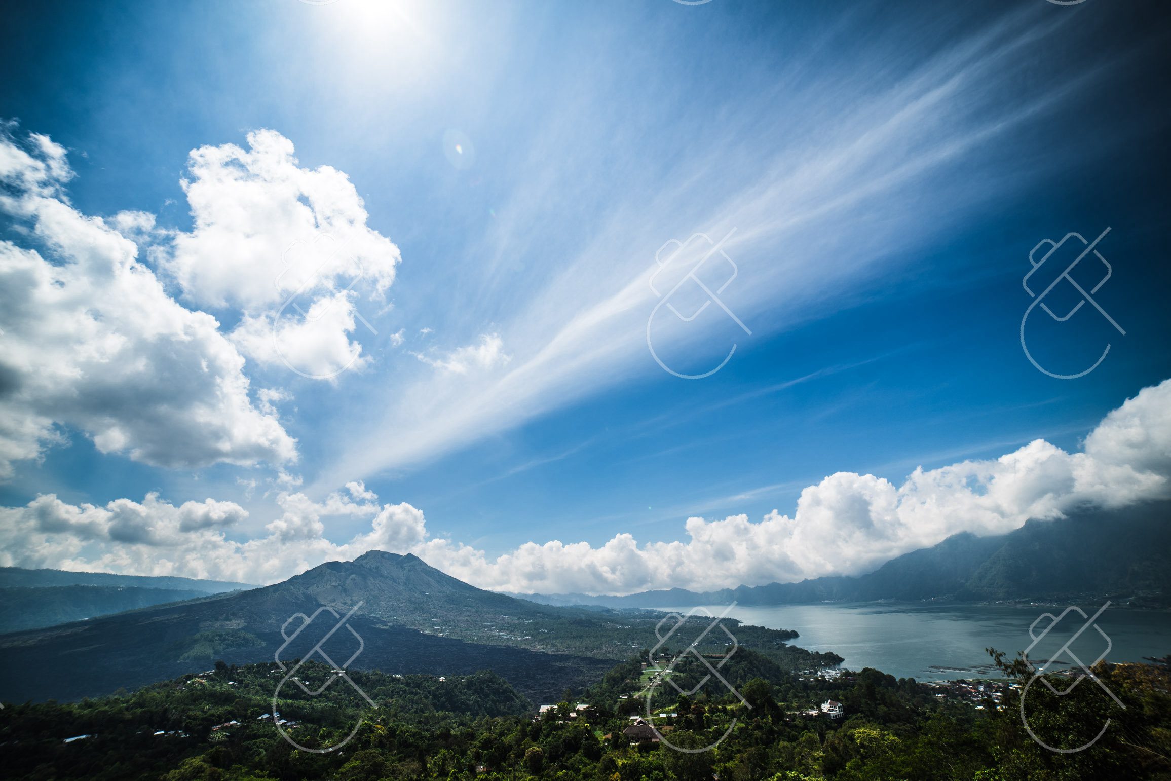
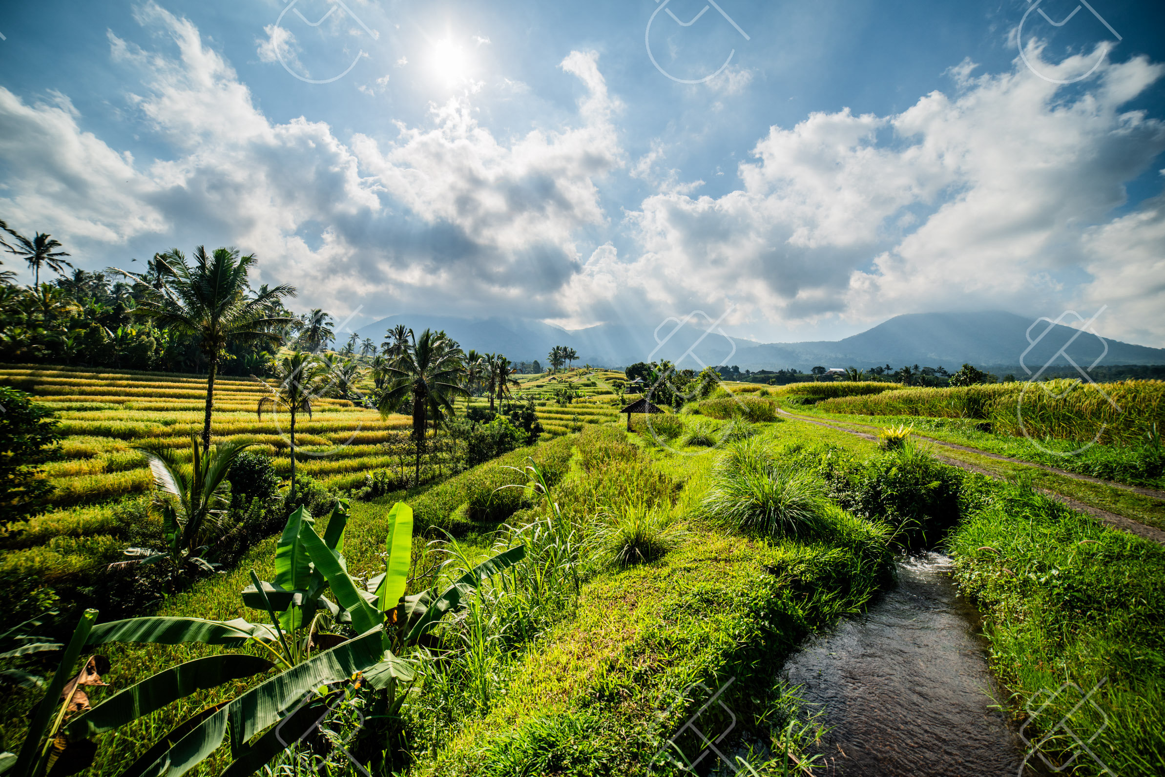
Sidemen is a rural valley in eastern Bali, set beneath the towering volcano of Mount Agung and known for its terraced rice fields, traditional weaving and an unhurried pace. It offers a landscape similar to Ubud's of decades past, with far fewer visitors.
The Sidemen valley unfolds in steep, sculpted rice terraces threaded by rivers, with the sacred peak of Mount Agung — at around 3,031 meters Bali's highest mountain and an active volcano — rising as a backdrop on clear days. The area has retained a strongly agricultural and traditional character, and is a center for the weaving of songket and endek, fine handwoven textiles produced on the island.
Walking trails wind between the paddies and through small villages, passing temples and plantations, and the valley is prized by photographers for its layered terraces and the looming cone of Agung. Mount Agung is deeply revered in Balinese Hinduism and is the site of Pura Besakih, the Mother Temple, the largest and holiest temple complex on the island, located on its slopes a short distance away.
When to go: April to October offers the driest weather for this tranquil valley's rice fields and Mount Agung views; the wet season is greener but brings frequent rain.
Where to stay: Guesthouses and small resorts on the valley ridges around Sidemen give terrace and volcano views, well placed for walks among the paddies.
What to eat: Simple warung fare of nasi campur and grilled dishes using the valley's rice and produce, plus local arak in some areas.
Tip: Mount Agung clears most reliably at dawn before cloud builds over the peak, so early mornings give the best chance of the volcano rising above the terraces.
Explore Sidemen →See every destination from the 526-day journey:
Browse all destinationsCurious about the gear behind these photos? See the gear list.